GRAN PARADISO TRAVERSE
Gran paradiso traverse :
Gran Paradiso traverse
7 DAYS, SELF-GUIDED
We’ll take care of organizing your 7-days/6-nights Gran Paradiso traverse. So, let you guided through its magnificent landscapes!
The Gran Paradiso massif is located in the Italian Alps, between the regions of Valle d’Aosta and Piemonte ; close of the Mont-Blanc and Monte Rosa massifs.
Europe’s first park ; « Il Parco Nazionale del Gran Paradiso » covers more than 70,000 hectares!
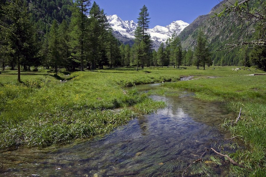
Wild and alpine, our itinerary takes in contrasting landscapes: larch forests, flowery meadows and high-mountain landscapes. A harmonious combination that offers sublime natural spectacles!
The typical mountain villages and hamlets contribute to the charm of the whole territory, where the traditions and customs of the Valle d’Aosta feed a strong, rich and lively culture. Our Valdostan cousins speak French with a touch of accent that adds an incomparable charm to this trek: a true journey!

Discover mid and high-altitude peaks, including Gran Paradiso: a 4,061-meter peak. The highest peak entirely in Italy!
Searching Availability...
7 DAYS, SELF-GUIDED :
A guided tour, with complete autonomy!
Day 1: Hamlet of Usellières – Refuge de l’Epée.
The hike starts at the hamlet of Usellières in the Valgrisenche – Aosta Valley. The path climbs across a beautiful forest of arolle pines to reach the first alpine pastures. The refuge de l’Épée is located beyond the forest in the first mountain pastures.
Optional: For those who wish to walk further, it is possible to make a round trip in the Fenêtre valley.
Approximate distance: 4.6 km – Elevation gain & loss: +585m / -4m.
Day 2: Refuge de l’Epée – Refuge Mario Bezzi.
The itinerary is that of the Alta Via 2, the path of the high glacial route. It reaches the Mario Bezzi refuge by small climbs and some rare descents. A detour to the lake of St Martin, above the Mont Vaudet is recommended before considering the descent to the Mario Bezzi refuge (2284m).
Approximate distance: 12.2 km – Elevation gain & loss: +781m / -869m.
Day 3: Refuge Mario Bezzi – Val di Rhêmes.
The path leads to the Bassac Déré pass (3082 m) and if you feel like it, to the Bec de la Traversière (3337m), a splendid viewpoint. The Vanoise, the Mont-Blanc and the Swiss Alps including the Matterhorn offer a unique spectacle. The descent allows you to reach the Benevolo refuge located in the Rhêmes valley (2285m).
Approximate distance: 10.4 km – Elevation gain & loss: +859m / -851m.
Day 4: Val di Rhêmes – Refuge Savoia.
To join the Rosset pass, it is necessary to go up the valley of the Gran Vaudala. The colorful alpine pastures mix with the black and grey scree that clings to the steep slopes. The passage of the pass is wonderful. We will appreciate the softness of the plateau with the altitude lakes. The Savoia refuge (2592m) which is named of the latest king of Savoy, Victor Emmanuel, is located at the Nivolet pass in the Valsavarenche.
Approximate distance: 10.2 km – Elevation gain & loss: +891m / -643m.
Day 5: Refuge Savoia – Eaux Rousses.
From the Savoia refuge, a long traverse in the direction of the Meyes valley and the Col della Manto (2795m) leads to the Entrelor valley and its Djouan lake. A majestic crossing, in front of the Gran Paradiso and the Grivola peak. The descent reaches the bottom of the valley and the hamlet of Eaux Rousses. Night at the hostel.
Approximate distance : 19.7 km – Elevation gain & loss: +688m / -1551m.
Day 6: Eaux Rousses – Refuge Vittorio Sella.
An early start is recommended in order to consider the long and magnificent climb to the Lauzon pass (3296m), which is the highest non-glacial pass in the park accessible to hikers. The steep descent among the limestone and schistose rocks, then the grassy meadows is often the ideal place to meet the ibexes of the Vittorio Sella refuge (2584 m).
Approximate distance: 17.3 km – Elevation gain & loss: +1669m/ -763m.
Day 7: Refuge Vittorio Sella – Cogne.
A formidable balcony route leads to the bottom of the cirque de l’Herbetet on the eastern side of the Grand Paradis. It is a vast glacial cirque which hosts numerous glaciers and the major summits of Valnontey. The descent reaches the eponymous village and later on the superb village of Cogne.
Approximate distance: 17.2 km – Elevation gain & loss: +185m / -1219m.
Note: the route, distances and altitudes can vary a little for many reasons beyond our control, including weather and terrain conditions.
Please also be aware that self-guided trekking involves your own responsibility for the route you choose and the choices you make on the trails. We will provide you with a roadbook and GPX tracks but you will be hiking every day on your own and we cannot be responsible for the decision and events that may occur during your hike.
Included / Not included :
Included :
- Accommodation: 5 nights in dormitory and 1 night in private room.
- Meals: 6 breakfasts and 6 dinners.
- Travel information: roadmap, GPS tracker, map for 2 people.
- Assistance of our team on site.
- Transfer from Chamonix to Usellières on day 1.
Not included :
- Repatriation assistance and cancellation insurance.
- Accommodation for one night before the trip (day 0) and one night after the trip (day 7).
- Transfers during the stay if necessary.
- Transfers to and from Chamonix and Cogne on day 7.
- Lunches, snacks and personal expenses.
- Everything not indicated in the “included” section.
Options on request : Contact us
- Transfers to Chamonix and from Cogne.
- Accommodation in Chamonix.
- Accommodation in Cogne.
Level: Beginner | Period: from July to September | Group size: unlimited | Self guided | Destination: Italy.
Our team will contact you after your booking on our website, to find out your preferred departure date. If we cannot find a satisfactory departure date, we will refund your deposit.

Discover also…
